Directions to The Mountain Institute’s
Spruce Knob Mountain Center
Spruce Knob Mountain Center
Spruce
Knob Mountain Center
18
Woodlands Way
Circleville,
WV
(304) 567-2632
or (304) 567-2644
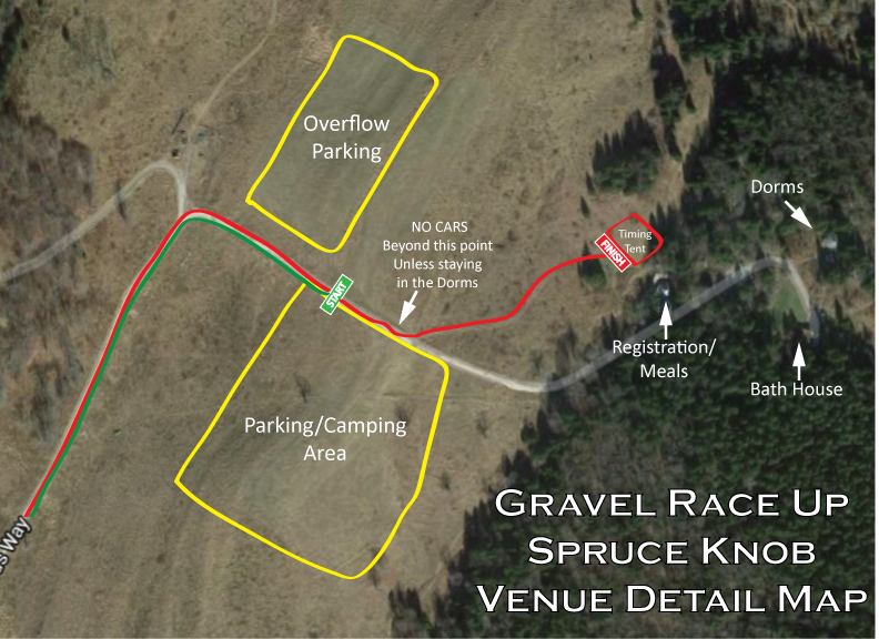
***I can't stress this enough, there is limited cell service in this area, make sure you're using a real GPS device or have the maps loaded in your phone before starting the trip and as always, it's a good practice to always have a printed map with you!***
FROM
WASHINGTON D.C., AND POINTS NORTH
- Follow I-81 South to the exit for Route 55/48 West (about three miles).
- Take 55/48 across the WV line, through the town of Wardensville, and at the other end of town it comes the Corridor H superhighway (still 55/48). Take the Moorefield exit.
- At the light at the T at the end of the exit ramp at Moorefield, make a left and just stay on Rte. 28 through Moorefield and Petersburg (you’ll have to make a right turn in “downtown” Petersburg, then go up the hill past a Dairy Queen and on out of town).
- Continue on Route 28 through Seneca Rocks.
- At Judy Gap, turn right onto 28 South and follow directions from Judy Gap on (below).
FROM
POINTS WEST
- Follow I-79 into West Virginia and to exit 99 (Route 33 East) at Weston and Buckhannon.
- Follow Route 33 East through Buckhannon and Elkins.
- The quickest route involves many miles of dirt and gravel roads through spectacular scenery. If you don’t like driving on rough roads, or are driving a bus, Rte 33 continues to Seneca Rocks where you can pick up Rte 28 South as above (from points North).
- If you like to see the country, turn right onto Rich Mtn. Rd, which becomes Whitmer Rd./Co.Rte. 29 at the town of Job, passing into the National Forest backcountry.
- If you miss Rich Mtn Road, you’ll have another chance at Whitmer Road at the bottom of the mountain before Harman.
- Stay left on Forest Road 1 passing Spruce Knob Lake and SK Lake Campground.
- Take your first right at the end of the pavement onto Forest Road 112.
- Turn slight left onto Sawmill Run Rd./Co. Rte 28/10.
- TMI will be on your left at the top of the ridge.
FROM
POINTS SOUTHWEST
- Follow I-64 to exit 175 onto 60 E.
- Follow 60 E through White Sulfur Springs to 92 N.
- At Dunmore, turn right onto 28N.
- Turn sharp left on Sawmill Run Road. [If you see the Circleville USPO, you missed it.] Follow the directions from Judy Gap below.
FROM
POINTS SOUTHEAST
- Follow I-64 W to I-81 N to Harrisonburg
- At exit 247, take US 33 W to Judy Gap. See directions from Judy Gap below.
FROM
JUDY GAP, WV
- Follow Route 28 South through Circleville (3 miles) and Cherry Grove (3 miles).
- Approximately 2–3 miles after going through Cherry Grove, turn right on Sawmill Run Road/Co. Rte. 28/10 toward The Mountain Institute and Spruce Knob Lake (there will be a small Forest Service sign).
- After about 3 miles continue left at the intersection with Hunting Ground Road another 3 miles to our sign and entrance on the right at the top of a hill; if you go down a very long hill and over a bridge at a small creek you have gone too far.
- Inside the entry you can park if checking in at our Earth Sheltered office building, if not, continue up the left fork through a blue farm gate.
- Follow the dirt road 1 mile through farm land (bearing right at our motor pool) until you get to the large round buildings—yurts.

No comments:
Post a Comment